
Reno Airport to The Expanding Light
Download PDF (155kb)
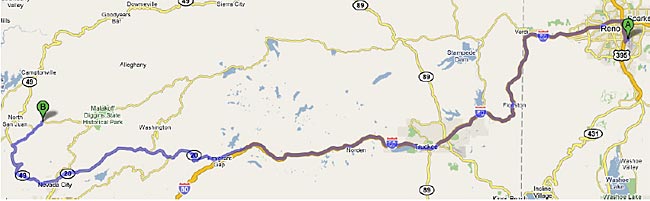
| Mileage | Directions |
| 0.0 miles | Head NORTH toward E PLUMB LN |
| 0.4 miles | Merge onto US-395 N via the ramp to I-80 |
| 3.0 miles | Take exit 68 to merge onto I-80 W |
| 61.2 miles | Take exit 161 for CA-20 W toward GRASS VALLEY/NEVADA CITY |
| 61.6 miles | Slight RIGHT at CA-20 |
| 88.1 miles | Turn RIGHT at CA-49 (signs for CA-49 N/DOWNIEVILLE) |
| 98.6 miles | Turn RIGHT at TYLER FOOTE ROAD towards MALAKOFF DIGGINS STATE PARK |
| 103.4 miles | Turn LEFT on ANANDA WAY |
| Almost immediately | Turn LEFT on EXPANDING LIGHT WAY |